
Knowledge Base Top 5 usability resources for location-based services
Are you designing a location-based service, but you're not sure where to start when it comes to usability? Then this article is for you.
Location-based services include mobile map applications, location-based advertising, alerts for traffic jams, delivery services, and apps that recommend local businesses or events.
They combine geospatial technologies, such as GPS, with other technologies to provide specific information to users based on their location - usually in real time. This doesn’t always mean GPS - mobile data, wifi and Bluetooth can all be used to provide location data.
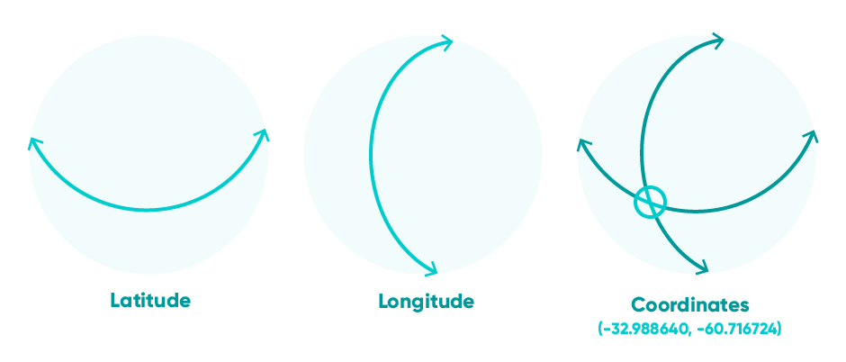
The geographic position of location data is described using coordinates, usually expressed in latitude and longitude.
Location APIs
Are you unsure about which method of location data capture is right for your application? The good news is there’s no need to build it from scratch. Location APIs can turn an individual’s location, such as their coordinates, into usable data, such as a street address. It works both ways:
-
Rooftop geocoding proves rooftop accurate coordinates for addresses.
- Reverse geocoding turns coordinates into street addresses.
This is a great way for your user to specify their address if they’re somewhere they’re not normally - for example they’re at a venue trying to take a taxi back home. Postcoder provides rooftop-level geocoding and reverse geocoding for the UK and Ireland.
Precision and accuracy
How accurately can you record your users location? And how precisely should you? The two questions are interlinked - if you can guarantee that you’re capturing accurate data, then you can record it with a confident level of precision. However, if your data is likely to be vague - for example if your users are in a multi-storey carpark - then it’s not worth trying to pinpoint them down to a couple of square meters.
At its most granular, GPS data can place your user within a 10m radius (and wifi and Bluetooth offer even more detail). When you capture GPS data, you can also discover how accurate that measurement is.
However, if you really need to know a specific location for your user that’s not tied to a street address, then you need a user-friendly way for them to enter that themselves. Coordinates are unwieldly for non-expert users (read: most of us), so there are several innovative solutions such as What3Words that allow people to describe their location accurately.
For indoor applications, such as an art gallery, Bluetooth beacons can be used to provide effective contextual information to a high degree of accuracy.
Location, Location, Location data
If you need to cross reference your location data with other datasets, then make sure the API you choose supports this. Ordnance Survey AddressBase Core and AddressBase Premium are the most authoritative location datasets in the UK.
The ONS Postcode Directory is a dataset that assigns administrative fields to postcodes. If your service is likely to require details such as NHS area codes or CCG codes from your users, then this is the dataset you need.
All these datasets provide a remarkable level of detail for addresses and non-address objects in the UK. However it’s also important to bear in mind when you’re capturing your user’s location data that there’s no reason to collect more information than you need. And if you intend on storing this data, make sure you’re not attaching personal or identifiable data to each data file. This isn’t something that directly affects usability, but it will prevent exploitation of your user data.
Design for the platform - and the location
When most people take a stab at their mobile phone screen, each tap represents an area about 36 pixels across. When this 36-pixel peck launches the user to the other side of town on the tiny map they’re squinting at, you’ve got a usability problem.
Take a walk in your customer’s shoes to discover how usable your service really is. Are they using your app in bright sunlight, making it hard to read the map you’re presenting? Are the turn-by-turn directions inaudible over traffic noise? Or are your users sat at desks with wide screen monitors, zooming in to get an extra level of detail for their reports? Context is everything in usability, and location services are no exception.

Make sure you’ve carried out detailed research, such as user journeys, before you begin designing, and test test test at every stage along the way. Testing prototypes of your service is the best way to ensure your interface is exactly as detailed as you need it to be. Adobe has some great tips to get you started on Map UI design.
Now where was I?
Does your user know where they are already? For example, would they be using your service at home, or the office, or while travelling? If your users want to override the location data provided by GPS, then you will need some form of manual data input.
This is all about user control and efficiency - cornerstones of a great user experience. For your users to retain a sense of control while using the app, while also making it as user friendly as possible, you need to find the most efficient way for users to input their location.
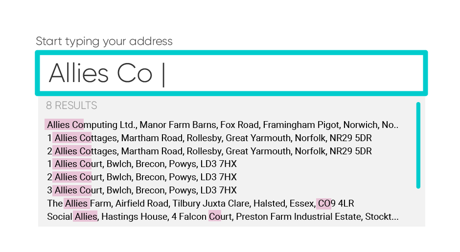
An address autocomplete API is a great way of providing this. Instead of multiple address fields, the user simply has to start typing their address, then select the correct address from the list. A good autocomplete API can also correct common errors or compensate for typos. Who can remember their friend’s postcode off the top of their head when they’re ordering a bunch of flowers, or a pizza for dinner? Autocomplete also works brilliantly when a user doesn’t know the details of a full address.
Takeaways
When location services really work, they’re invaluable. However, you need to put your users’ needs first:
- Only gather as much location data as you need to, when you need to.
- Be flexible enough to allow your users to take control when they need to.
- Make use of existing location data APIs to ensure the data you collect is accurate enough to meet both your and your users’ needs.


