Knowledge Base Premise level or postcode level co-ordinates?
Don't reach for the magnifying glass when you need a microscope
Knowing where customers are physically located is vital for marketing, sales, and executive teams to see how their business is performing with certain demographics.
Back of house, co-ordinate information is used by logistics and service teams to pin-point locations for site visits and works on utilities.
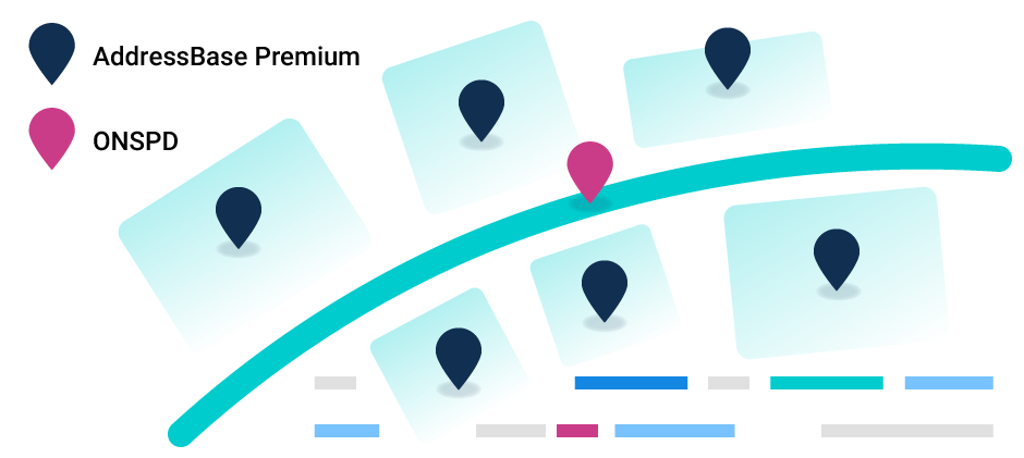
For Great Britain, there are a few main sources for this co-ordinate data. ONSPD from the Office of National Statistics (ONS) provides postcode-level geodata, while AddressBase by Ordnance Survey (OS) contains premise-level geodata.
Both are effective tools, but only if used for the job they’re intended to do.
ONS vs OS
ONSPD (ONS Postcode Directory) provides a latitude and longitude for every postcode in mainland Great Britain.
These co-ordinates can be called through Postcoder using our geodata endpoints. If a website has ever asked for your postcode to provide information relevant to your local area, then there is a good chance you have used ONSPD data.

But, as this data is only accurate down to the postcode level, it is not effective if a business attempts to use it to pin down the exact location of a particular address.
For example, house numbers 1, 2, and 3 within the same postcode will all share the same latitude and longitude using this level of data, even if they are completely separate buildings.
The granularity of postcode level data is absolutely fine for many business purposes, as it is an inexpensive option for showing an approximate location for a premise. And, since all addresses within a postcode shouldn’t be too far from each other, this is usually OK.
When put into practice, however, some rural postcodes end up spread out over considerably more than a walkable distance.
Let’s look at IV4 7JX, near Inverness, in Scotland. This postcode is nearly 20km (12 miles) from end to end if plotted on a map using premise-level geodata.
It’s impossible to even see this issue when looking up IV4 7JX using postcode-level data - this data simply shows a single pin in a map, with no indication that addresses within that postcode stretch out for 10km both east and west of that pin.
Because of this, some business processes will require more precision than a postcode level latitude and longitude to locate an address.
Surveyors and building contractors need to know exactly which premise to visit when house numbers aren’t present; delivery couriers need precise directions to a building when a postcode-level co-ordinate isn’t accurate enough; schools need to pin-point exactly which houses fall within their catchment area.
For these situations, Ordnance Survey’s suite of AddressBase data products provide the added level of granularity that many businesses rely on.
Which should we choose?
Let’s take a look at the example of postcode NR6 5DR, which covers a business park in Norwich.
Postcode-level geodata would be sufficient to find the business park itself using a satnav, but carrying out a delivery to one of the businesses on the park would require the driver to use local cues to find the correct building.
This is made all the more challenging by the fact that only a few of the roads on this business park have unique names. For this delivery driver, premise-level geodata would save a lot of time hunting for a single address.
On the other side of the coin, business owners needing to display exactly where their own stores and locations are, perhaps in a store-finder application on their website, will benefit from allowing AddressBase to do the hard work.
If you have more than a few locations across the country, pinning down the exact location for each one would be a time consuming process using postcode-level data. AddressBase has already done the hard work finding the precise premise-level location of each store, saving you a potentially significant amount of manual work.
There have recently been reports of couriers who only use postcode-level data to confirm deliveries being targeted by thieves. Amazon and eBay deliveries are most frequently targeted, but if you’re running an e-commerce business, it’s worth checking to see if your courier uses premise-level or postcode-level data, to avoid leaving yourself vulnerable to parcel fraud.
Great! Where do I start?
Premise-level co-ordinates sound like they would be the obvious choice. But, being a premium data resource, it can come with a larger price tag. No successful business spends money that it doesn’t need to spend, so take the time to consider which level of data is appropriate for your needs.
In some cases, premise-level data simply isn’t required. If you are collecting geodata for demographic reasons, it may not be important to know where within a postcode a particular premise is. It will usually be enough to know which general area the customer is in.
Whichever level of data your business needs, PostCoder is available to provide it.
More information on setting up your application or site to find premise-level geodata can be found on our developer documentation. When you’re ready, simply get in touch with us to request a trial of premise-level geodata on your account.
Postcode level geodata doesn’t need to be activated for you to start testing. Simply use the /addressgeo/ endpoint and search for addresses as normal.
Alternatively, if you don’t need the address data and just want to turn postcodes into co-ordinates, the /position/ endpoint is here for you.
Ready to get started? Come and speak to us.
 ONSPD
ONSPD AddressBase Premium


